November 5th, 2006
a year in the life of a stream
Yesterday, Don and I spent the afternoon hiking the trails at Murphys Point Provincial Park. A favourite walk takes us on a route that crosses Black Creek twice. Each time we do this hike, I try to remember to shoot photos of the creek from roughly the same vantage points. I’ve been doing so for several years, so have some idea of how the creek looks through the seasons from year to year.
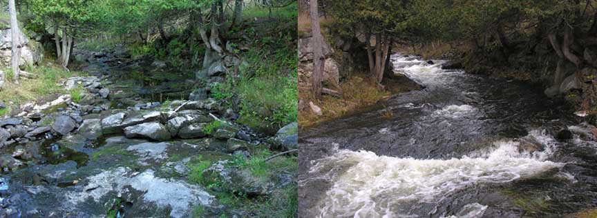
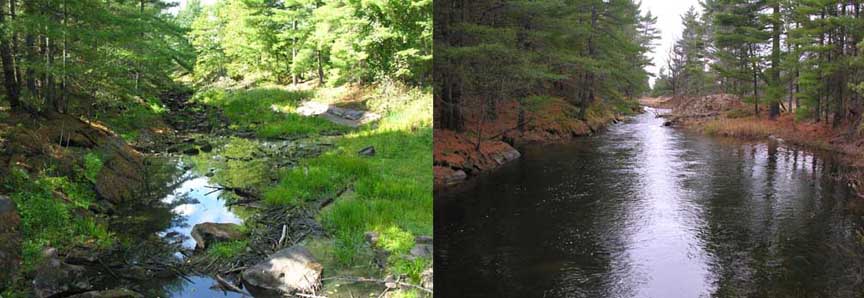
Above and below are pairs of photos taken from similar vantage points at two favourite spots along the creek. The above shots were taken looking upstream from the footbridge not far from the McParlan House cabin. The one on the left was taken on Sept. 18, 2005, and the one on the right was taken yesterday, Nov. 4, 2006. The lower set of photos are looking upstream from a vantage point on Black Ance Road. The angle is a little different, but the similarity of location should be apparent.
Last year was very dry in this region — one of several recent dry summers over the past few years. This autumn, we’ve been receiving an unusual amount of rain, so the streams are really flowing — as can be seen in the more recent photos. Levels are actually close to what we would expect to see in the springtime.
Yesterday, I also shot a couple of .mp4 movie clips. I’ve started making more of these to document places as I find that sometimes movie clips provide a bit better feel for a place than a still photo. The first clip is of the same section of creek as shown in the top pair of photos (about 25 sec. and 1.2 mb). The second clip was taken looking down into the water flowing from under the footbridge where I was standing while shooting the first clip (about 25 sec. and 1.2 mb). Although not audible in the soundtrack, the creek was making low, rumbling, muttering noises that resembled talking or humming. I’ve always loved listening to those strange sounds created when water rushes through and around rock. One of my favourite memories is of crouching low on a large, irregular-shaped boulder at the edge of a very fast-flowing river in Washington, feeling the vibration, and hearing the voice of the river as it pushed and swayed the rock beneath me. There’s something about it that reminds me of Kerouac’s poem about the sea sounds which appears at the conclusion of his novel, Big Sur. If we listen well, the voice of water maybe be found in many places.
Tags: Black Creek, Black Ance Road, Murphys Point Provincial Park, water levels, Jack Kerouac, Big Sur
November 5th, 2006 at 11:37 pm
The difference in the amount of water is pretty dramatic. Nice to see high level of water, although a bit disconcerting that it is spring level occurring in late fall. We’ve been having plenty of rain the past few days. We may even be in for some torrential rains on Monday. We sure could have used some of this rain in summer when the garden was parched, but I’m glad to see the grasses turning green.
It’s nice to be reminded of Kerouac’s poem. Makes me want to go look it up and read it again.
November 6th, 2006 at 1:11 am
Robin – I have to say that both extremes.. the dry and the high, seem a bit shocking when I see the photos side by side. I had forgotten just how dry things got by last autumn, but when I walked up the bed of Black Creek last September, I found many minnows trapped in little pools with nowhere to go. That was quite an unusual situation. To see it just the opposite this year is really quite odd. Probably good for the fish and other aquatic life though.
November 6th, 2006 at 10:12 am
I have to get back to Black’s Creek before the snow flies and listen to the water, and thank you for reminding me!
This year, there is much more water flowqing out on the Two Hundred Acre Wood in Lanark too. The beaver ponds are full to brimming, and in places where streams run only in springtime, there are little rivers everywhere now and tiny waterfalls gurgling. it’s lovely to hear this again before winter sets in and I potter off into the woods on my snowshoes.
November 6th, 2006 at 2:50 pm
Bev – I love flowing water, and combine that with before and after shots and I’m entranced. Those are particularly great – I’m struck by the clarity of the water after the rains too.
I have my own set, but the water during a full rainy period is very muddy.
November 6th, 2006 at 3:25 pm
Cate – We noticed that the water levels were high while out and about in Lanark too. I’m hoping to stop over at Blakeney Rapids sometime very soon as the Mississippi must just be roaring through there! I’ll definitely take some photos and post them.
–
Wayne – The water is quite clear in most rivers up on the Shield it runs through granite and not much soil. However, it does tend to be a bit tea-colored, probably due to both tannins from wood residues and from mineral in the rock. I’m planning to get around to a few other creeks and rivers before freeze-up to get some shots of high water conditions for future reference, so I may be posting some more of these comparison sets.
November 6th, 2006 at 6:27 pm
“Snowshoes.” “Before they freeze up.” “Before the snow flies.” What language are you speaking? :-)
I’d love to use snowshoes around here. Maybe in the mud.
November 6th, 2006 at 9:08 pm
It’s been quite a few years since I have hiked at Murphy’s Point. Thanks for the videos too, always watch them whenever you put them up
November 7th, 2006 at 5:47 pm
Wayne – Yes… “snowshoes” and “freeze ups” and “snow flies”. Very relevant to our region! When the snow comes, remind me to post some photos and maybe a little .mov clip of us tromping around in our snowshoes! (-:
—
Peter – We often hike at Murphy’s Point as we find that it’s one of the most reliable places to encounter interesting insects, birds and mammals. Charleston Lake Prov. Park is our other favourite. We love Frontenac Park as well, but it’s just a little too far to visit more than once or twice a year.
November 8th, 2006 at 12:48 am
Charleston Lake is deffinitly my hearts home, I missed it very much this summer not being able to visit. I should go check out your pbase gallery for some photos (and if you don’t have any up, I can beg, haha).
Frontenac has some great trails too. I have an interesting story from my childhood and there, but I’ll save it for another day :)
November 8th, 2006 at 1:17 am
Peter – I do have more photos from Charleston Lake up on my Pbase galleries. Here are links to a couple. These were taken on the Tallow Rock Bay Trail in late November 2003. The weather turned very warm that day and we were hiking in our t-shirts.
http://www.pbase.com/crocodile/tallow_rock_bay_trail
Same trail on Nov. 5, 2005 — also quite a warm day for the time of year.
http://www.pbase.com/crocodile/tallow_rock_11_2005
I was hoping that we might be able to do that Tallow Rock Bay Trail again this autumn after I returned home, but I think it may be too wet even if we get some nice weather. There’s a section of the trail that passes through some beaver-flooded forest and it can be a bit soggy in there in autumn, even in a fairly dry year. Might hike to Slim Bay and back though. We like to pack a lunch and hike to the long bridge across the bay and sit on one of the platforms while having a picnic late in the season when there is usually no one else around.